1. Introduction to GRSGIS
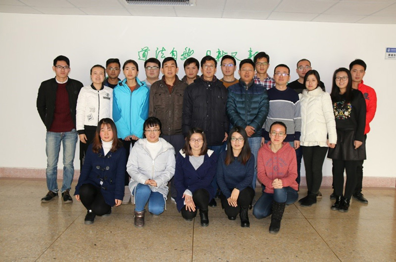
Grassland Remote Sensing and Geographic Information System Institute (GRSGIS) at College of Pastoral Agricuture Science and Technology (CPAST), Lanzhou University, has mainly focused on remote sensing of grassland agriculture, monitoring and early warning of snow-caused disaster, assessment of ecological risks and ecological health in pastoral areas, and information system development of grassland agricultural resources. Based on solid theoreitcal foundation, this team has rich experiences on field investigation of key factors in the alpine grassland vegetation and snow cover in the Qinghai-Tibet Plateau Region, remote sensing dynamic monitoring and evaluation, ecological security assessment in pastoral areas, information systems developent, and data mining and machine learning of BIG data.
Grassland Agricutural Information Laboratory (GAIL), a unit of the institute in CPAST, is a major branch of the State Key Laboratory of Grassland Ago-ecosystems (SKLGA), Lanzhou University, China. Grassland Agricutural Informatics is not only the key construction direction by "211" and "985" projects of the Ministry of Science and Technology, China, but also is an important branch in grassland science, ranked A+ in the fourth round of subject assessment, the Ministry of Education, China. The team currently consists of two professors, one associate professor, one senior engineer, one engineer, and nearly 30 graduate students.
In the past 20 years, this team has engaged in studing on grassland remote sensing, snow-caused disaster, information system research and development. We have reached a series of innovative achievements in the areas of snow cover assessment and early waring, natural vegetation classification and simulation, and development of digital grassland management decision support system in the pastoral areas of Northern Xinjiang and Qinghai-Tibet Plateau. We have successfully undertaken more than 30 national and provincial-level scientific research projects in Qinghai, Tibet, Xinjiang, and Gansu provinces. In the past 5 years, the research team completed 20 national and provincial projects, and published over 100 academic papers, including 50 SCI papers and five monographs, gained more than ten computer software copyrights and two patents, and won four achievement awards (one first place, two second place, and one third place) of science and technology advancement at the Gansu Province level.
2. Research Progress & Achievements
The research work and achievements of this team mainly include the following five aspects:
2.1 Global climate change and succession of grassland vegetation types
Using the comprehensive and sequential classification system (CSCS) theory proposed by Academician Ren Jizhou, the founder of pratacultural science, through combining with RS and GIS technologies and methods, the accuracy of CSCS at the global scale was verified, and the 1 km resolution series maps of vegetation succession dynamic change were produced at both global and regional scales (e.g., Qinghai-Tibet Plateau, entire China and the Northern Hemisphere) over the past 100 years (1901-2000) and the future in 2050 for the first time, revealing the current and future potential natural vegetation types and spatial distribution patterns and characteristics of NPP in responding to climate change. The data has been shared through an open and shared data management system (http:// cscs.ecograss.com.cn/) based on the Internet and GIS technologies. This research was funded by the National Natural Science Foundation and key Consulting Research Project of Chinese Academy of Engineering. The research team published a monogrph of “Advance in Grassland comprehensive and Sequential Classicification System” and more than 20 papers (including 7 SCI papers), won one first achievement award and one second achievement award of science and technology advancement of the Department of Education in Gansu Province, and obtained two computer software copyrights.
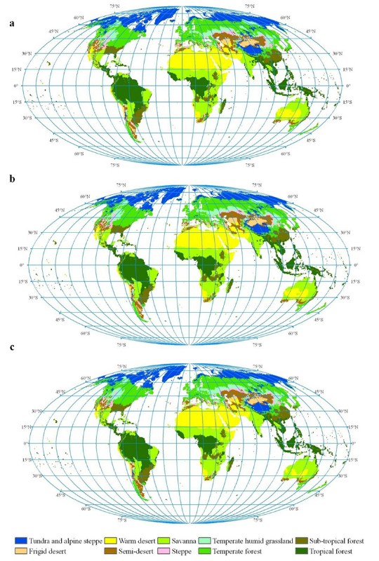
Fig.1 Spatial distribution of the natural vegetation categories at global scale in the periods from 1911 to 1940 (a), 1941 to 1970 (b), and 1971 to 2000(c)
2.2 Grassland resources and environment management information system
since 1999, under the support of the National Natural Science Foundation of China, the Government of Gansu Province, and the Western Special Project of the Ministry of Science and Technology, China, the team has developed more than 10 information systems and obtained 8 national computer softare copyrights. Among them, the "China Grassland Agriculture and Ecology" system (http://www.ecograss.com.cn), based on WebGIS and other technologies, was developed and launched in 2007. This system includes 23 national large-scale spatial databases related to soil, grassland, livestock and social economy, and 15 specialized knowledge bases covering herbage varieties, diseases, rodents and pests. This system realizes the main functions about the digital and visual query, retrieval and management of the basic information of grassland ecological environment, the adaptability of cultivated pasture varieties, and the diagnosis of grassland herbage diseases in almost all counties/cities of China, and can accurately answer "where", "what is", "what variety of herbage", "how to cultivate", "what variety of livestock", "how to raise", related grassland management techniques, and other relevant information. Since 2007, the number of users registered in the system has reached more than 5,000, and the system has also been linked to the National Science and Technology Infrastructure Platform - Earth System Science Data Sharing Platform (http://www.geodata.cn/). Our system and results have been widely used in grassland agricultural science teaching, research and production departments; the system has played an important role in the dissemination of grassland agriculture scientific knowledge and information sharing services. The research results won one second achievement award of science and technology advancement in Gansu Province in 2003 and one third achievement award in 2009.

Fig. 2 Homepage of the information system for China’s grassland agriculture and ecology
2.3 Remotely sensed monitoring of the key parameters of grassland vegetation
Using remote sensing and GIS techniques, the key factors affecting the biomass of alpine grassland in the Three-River Headwaters Region of China were identified, and a high-accuracy dynamic inversion model for grassland biomass based on artificial neural network (ANN) algorithm and MODIS remote sensing data was created. A remote sensing monitoring method for vegetation coverage based on unmanned aerial vehicle (UAV) technology and MODIS data was proposed to provide a more accurate and rapid quantitative method for the assessment of the growth conditions of large-scale grassland; a real-time monitoring approach about grassland vegetation height based on laser technology was proposed; and a rapid assessment model and device for grassland biomass based on grassland vegetation cover and height was proposed. Research in this area has been funded by more than 10 projects including the National “863” Plan, the National Science and Technology Support Program, and the Research Projects of the Ministry of Agriculture, China. The team gained two patents, and published more than 10 SCI papers in the Remote Sensing of Environment, Remote Sensing, New Zealand Journal of Agriculture Research, and other magazines.
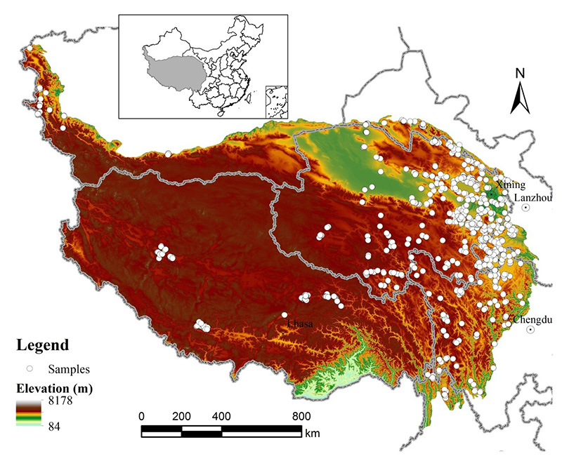
Fig. 3 Spatial distribution of the sampling sites during 2005 to 2006 and digital elevation model in Qinghai-Tibet Plateau
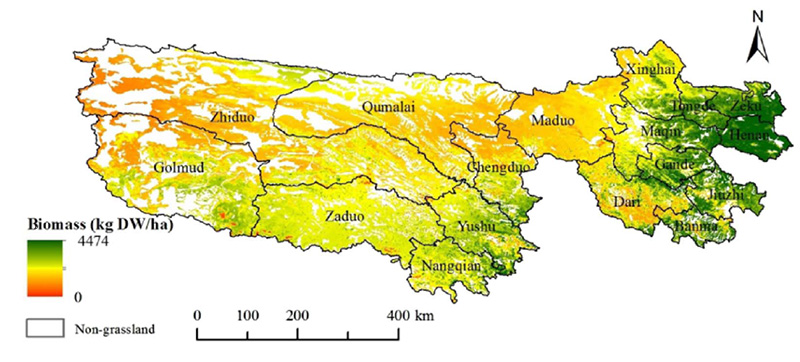
Fig. 4 Spatial distribution of the average grassland AGB in the TRHR from 2001 to 2016 (Yang et al., 2018)
2.4 Assessment of ecological risk and ecological health
For the eastern Tibetan Plateau alpine grassland, the team constructed an ecological risk evaluation index system and distributed warning system, and examined the risk types and their spatial distribution characteristics of each type. In this filed, we conducted the dynamic monitoring and evaluation about the health status and the risk degree of alpine grassland, systematically studied the influence of ecological risk on the service functions of alpine grassland, and put forward effective risk prevention and control measures for different grassland areas. The research in this field has been funded by four National Natural Science Foundation projects and one special research project from the Ministry of Agriculture, China. More than 30 scientific research papers have been published, including 5 SCI papers and 5 EI papers.
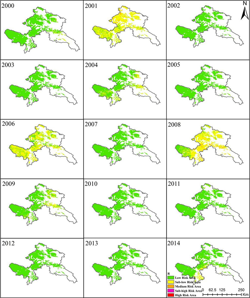
Fig. 5 Spatial distribution of the ecological risk classification from 2000 to 2014
2.5 Snow cover monitoring and early warning of snow-caused disasters
We developed an snow cover remote sensing dynamic monitoring method in the Northern Hemisphere, comprehensively evaluated the temporal changes of snow cover and snow-covered days in the Eurasia and Northern Hemisphere during the past 15 years; and we constructed a comprehensive risk evaluation model of snow disaster based on logistic regression analysis method, created a snow disaster early warning method and procedure based on machine learning algorithm of BP-ANN and multi-factors of average temperature, probability of snow disasters in spring, snow disaster comprehensive risk probability rate, average temperature below -5℃ and duration of snow cover. Since 2002, this field of research has been funded by four National Natural Science Fundation Projects and one project of the Ministry of Education, China, and innovative results in snow cover monitoring, and disaster risk assessment and early warning were achieved. More than 20 papers related to this research were pblished in the journals of Remote Sensing of Environment, The Cryosphere, Remote Sensing, International Journal of Remote Sensing and Journal of Hydrology.
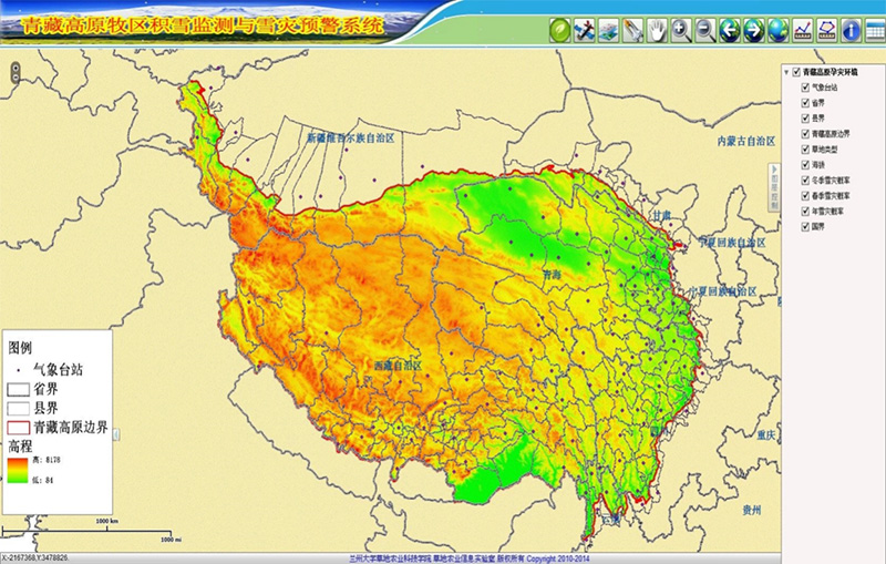
Fig. 6 Monitoring and early warnning system of snow-caused disasters in pastoral areas of Qinghai-Tibet Plateau, China
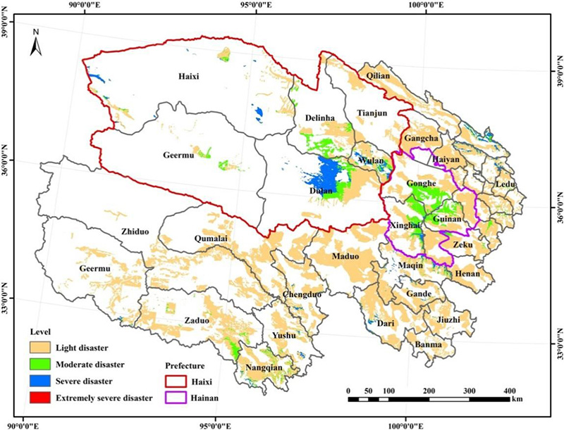
Fig. 7 Spatial distribution patterns of snow-caused disasters in Qinghai Province, China
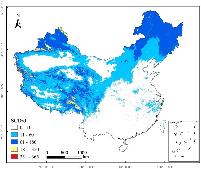
Fig. 8 Spatial distribution characteristics of yearly snow-covered days (SCD) in China
3.International cooperation
The cooperations with domestic and international relevant institutions in research and development of grassland agriculture informatics are highly valued by Grassland Remote Sensing and Geographic Information System Institute (GRSGIS). In past 20 years, we conducted a series cooperative studies with specialists from the United States of America, Canada, Austrilian, New Zealand, and etc. Especially, in recent decades, we closely cooperated with Prof. Hongjie Xie, the University of Texas at San Antonio, Prof. Xulin Guo, the University of Saskatchewan, and Prof. Knops, the University of Nebraska, to do research, training and education of graduate students and teachers in remote sensing of grassland enviroment, grassland ecology, and geographic informtion system.
4.Publications
[1] Yang Shuxia, Feng Qisheng, *Liang Tiangang, Liu Baokang, Zhang Wenjuan, Xie Hongjie. Modeling grassland above-ground biomass based on artificial neural network and remote sensing in the Three-River Headwaters Region. Remote Sensing of Environment, 2018, 204:448-455.
[2] Zhang Renping, *Liang Tiangang, Guo Jing, Xie Hongjie, Feng Qisheng & Aimaiti Yusupujiang. Grassland dynamics in response to climate change and human activities in Xinjiang from 2000 to 2014. Scientific Reports, 2018, 8: 2888, DOI: 10.1038/s41598-018-21089-3.
[3] Meng Baoping, Gao Jinlong, *Liang Tiangang, Cui Xia, Ge Jing, Yin Jianpeng, Feng Qisheng and Xie Hongjie. Modeling of Alpine Grassland Cover Based on Unmanned Aerial Vehicle Technology and Multi-Factor Methods: A Case Study in the East of Tibetan Plateau, China. Remote Sensing. 2018, 10, 320; doi:10.3390/rs10020320.
[4] Yunlong Wang, *Xiaodong Huang, Hui Liang, Yanhua Sun, Qisheng Feng, Tiangang Liang. Snow cover changes in the northern hemisphere under warming climate using multi-source remote sensing data (2000-2015) . Remote Sensing, 2018, 10, 136; doi:10.3390/rs10010136.
[5] Meng Baoping, Ge Jing, *Liang Tiangang, Yang Shuxia, Gao Jinglong, Feng Qisheng, Cui Xia, Huang Xiaodong and Xie Hongjie. Evaluation of Remote Sensing Inversion Error for the Above-Ground Biomass of Alpine Meadow Grassland Based on Multi-Source Satellite Data. Remote Sensing. 2017, 9, 372; doi:10.3390/rs9040372.
[6] Gao Jinlong, *Huang Xiaodong, Ma Xiaofang, Feng Qisheng, Liang Tiangang and Xie Hongjie. Snow Disaster Early Warning in Pastoral Areas of Qinghai Province, China. Remote Sensing. 2017, 9, 475; doi:10.3390/rs9050475.
[7] *Huang Xiaodong, Deng Jie, Wang Wei, Feng Qisheng, Liang Tiangang. Impact of climate and elevation on snow cover using integrated remote sensing snow products in Tibetan Plateau. Remote Sensing of Environment, 2017, 190:274-288.
[8] Liang Hui, *Huang Xiaodong, Sun Yanhua, Wang Yunlong & Liang Tiangang. Fractional Snow-Cover Mapping Based on MODIS and UAV Data over the Tibetan Plateau. Remote Sensing, 2017, 9, 1332; doi:10.3390/rs9121332.
[9] *Liang Tiangang, Yang Shuxia, Feng Qisheng, Liu Baokang, Zhang Renping, Huang Xiaodong, Xie Hongjie. Multi-factor modeling of above-ground biomass in alpine grassland: A case study in the Three-River Headwaters Region, China. Remote Sensing of Environment, 2016, 186:164-172.
[10] *Huang Xiaodong, Deng Jie, Ma Xiaofang, Wang Yunlong, Feng Qisheng, Hao Xiaohua, and Liang Tiangang. Spatiotemporal dynamics of snow cover based on multi-source remote sensing data in China. The Cryosphere, 2016, 10: 2453–2463.
[11] Zhang Renping, *Liang Tiangang, Feng Qisheng, Huang Xiaodong, Wang Wei, Xie Hongjie and Guo Jing. Evaluation and adjustment of the AMSR2 snow depth algorithm for the Northern Xinjiang region, China. IEEE Journal of Selected Topics in Applied Earth Observations and Remote Sensing, 2016, DOI:10.1109/JSTARS.2016.2620521.
[12] Wang Wei, *Huang Xiaodong, Deng Jie, Xie Hongjie and Liang Tiangang. Spatio-Temporal Change of Snow Cover and Its Response to Climate over the Tibetan Plateau Based on an Improved Daily Cloud-Free Snow Cover Product. Remote Sensing, 2015, 7, 169-194; doi:10.3390/rs70100169.
[13] Deng Jie, *Huang Xiaodong, Feng Qisheng, Ma Xiaofang and Liang Tiangang. Toward improved daily cloud-free fractional snow cover mapping with multi-source remote sensing data in China. Remote Sensing, 2015, 7, 6986-7006. Doi:10.3390/rs70606986.
[14] Wang W., *Liang T., Huang, X., Feng, Q., Xie H., Liu X., Chen M. and Wang X. Early warning of snow-caused disasters in pastoral areas on the Tibetan Plateau. Natural Hazards and Earth System Sciences, 2013, 13: 1411–1425.
[15] *Liang Tiangang, Feng Qisheng, Cao Jianjun, Xie Hongjie, Lin Huilong, Zhao Jun, Ren Jizhou. Changes in global potential vegetation distributions from 1911 to 2000 as simulated by the Comprehensive Sequential Classification System approach. Chinese Science Bulletin, 2012, 57(11):1298-1310.
[16] Yu Hui, Zhang Xuetong, *Liang Tiangang, Xie Hongjie, Wang Xianwei, Feng Qisheng and Chen Quangong. A new approach of dynamic monitoring of 5-day snow cover extent and snow depth based on MODIS and AMSR-E data from Northern Xinjiang region. Hydrol. Process. 2012, 26, 3052–3061.
[17] Cui Xia, *Guo Zhenggang, Liang Tiangang, Shen Yuying, Liu Xingyuan, Liu Yong. Classification management for grassland using MODIS data: a case study in the Gannan region, China. International Journal of Remote Sensing, 2012, 33(10): 3156-3175.
[18] Huang XD, *Liang TG, Zhang XT, Guo ZG. Validation of MODIS snow cover products using Landsat and ground measurements during the 2001–2005 snow seasons over northern Xinjiang, China. International Journal of Remote Sensing, 2011, 32(1):133-152.
[19] Huang XD, Xie HJ, Liang TG, Yi DH. Estimating vertical error of SRTM and map-based DEMs using ICESat altimetry data in the eastern Tibetan Plateau. International Journal of Remote Sensing, 2011, 32(18):5177-5196.
[20] Liang Tiangang, Zhang Xuetong, Xie Hongjie, Wu Caixia, Feng Qisheng, Huang Xiaodong, Chen Quangong. Toward improved daily snow cover mapping with advanced combination of MODIS and AMSR-E measurements. Remote Sensing of Environment, 2008,112:3750-3761.
[21] Liang Tiangang, Huang Xiaodong, Wu Caixia, Liu Xingyuan, Li Wenlong, Guo Zhenggang, Ren Jizhou. An application of MODIS data to snow cover monitoring in a pastoral area: A case study in Northern Xinjiang, China. Remote Sensing of Environment. 2008,112: 1514-1526.
[22] Liang Tiangang, Liu Xingyuan, Wu Caixia, et al. An evaluation approach for snow disasters in the pastoral areas of northern Xinjiang, PR China. New Zealand Journal of Agricultural Research. 2007, 50(3): 369-380.
[23] Liang Tiangang, *Chen Quangong, Ren Jizhou, Wang Yuansu. A GIS-based expert system for pastoral agricultural development in Gansu Province, PR China. New Zealand Journal of Agricultural Research. 2004, 47: 313-325.
[24] Li Jianlong, *Liang Tiangang, Chen Quangong. Estimating grassland yields using remote sensing and GIS technologies in China. New Zealand Journal of Agricultural Research. 1998, 41(1):31-38.
Add:jiayuguan west road 768 lanzhou gansu,730000 Tel:0931-8913074 Fax:0931-8913074 陇ICP备10000336号
Copyrights © All Rights Reserved. School of Pastoral Agriculture Science and Technology